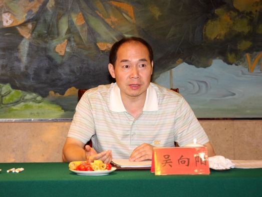
Name: Wu Xiangyang
Academic title: Associate Professor
Positions: Director of satellite navigation and positioning laboratory in Transportation College, SEU. Director of geographic information department in key laboratory of field investigate and survey of the Ministry of Land and Resources
Research directions: Satellite navigation and positioning theory, Modern measurement data processing, 3S technology integration
E-Mail: gpsadj@163.com 、wxy379@sina.com
Introductions:
Wu Xiangyang, male, was born in July ,
Background:
1983.9-1987.6 Studied on geodetic surveying in Wuhan Technical University of Surveying and Mapping
1987.7-2000.3 Teached in the Department of Surveying and mapping , the former Nanjing Geological School
2000.4-2013 Work in department of surveying and engineering in Transportation College of South-east University, key laboratory of field investigate and survey of the Ministry of Land and Resources
Monographs, Teaching materials, Papers
[1]Shen Xuebiao、Wu Xiangyang. GPS positioning technology. Beijing: China Architecture &Building Press. 2003.06.
[2]Hu Wusheng、Gao Chengfa. Principle and Application of GPS Survey. Beijing: China Communication Press. 2002.10.
[3]Zhang Shushou、Su Zaihong、Wu Xiangyang.Cadastral Investigation and Cadastral Surveying. Beijing: Surveying and Mapping Press.2008.08.
[4]Gao Chengfa、Hu Wusheng. Principle and Application of Satellite Navigation and Positioning. Beijing: China Communication Press. 2011.09.
[5]Li Yubao、Shen Xuebiao、Wu Xiangyang. Control Surveying. Nanjing: South-east University Press. 2013.02.
[6] Wu Xiangyang, Wang Qing, Gao Bing, Liang Hongbao. The Study on the Synthesis Approximate Algorithm of GPS Height Conversion .2009.11.
[7] Wu Xiangyang,Wang Qing,Wang Yan and so on. Research of the land change investigation mode based on ‘double stars’ combination. Bulletin of Surveying and Mapping,2008.8.
[8] Wu Xiangyang,Wang Qing,Li Chuanjun. Research and realize the key technology of land survey on-board. Bulletin of Surveying and Mapping,2009.3.
[9] Wu Xiangyang,Wei Xiaoning. Handling some special problem about GPS network adjustment. Bulletin of Surveying and Mapping,2004.7.
[10]Liang Hongbao,Wu Xiangyang,Wang Huiqing. Research on large-scale GPS coordinate transformation based on Delaunay triangulation network. Surveying and Mapping Engineering,2012.1.
[11]Wu Xiangyang, Wang Qing, Tao Chuanda. Research on coordinate transformation of GPS/TPS/PDA integrate mapping system.The National Conference on traffic engineering measurement, 2011.11.
[12]Wu Xiangyang, Li Ping, Tao Chuanda. Research on compatibility of GPS common points on road.The National Conference on traffic engineering measurement, 2011.11.
Projects
1.Key technology research on achieving basic information of village planning, National Science & Technology Pillar Program during the Eleventh Five-year Plan Period 2006BAJ
2.Technology integration and demonstration of developing rural community after disaster in south Shaanxi. National Science & Technology Pillar Program during the Eleventh Five-year Plan Period 2008BAK51B04, 2006-2010. Branch project leader.
3.Research on standard of land patrol vehicles. Public sector funds of the Ministry of Land and Resources during the Eleventh Five-year Plan Period 200811107, 2008-2010. Project leader.
4.Acquisition and processing of domestic satellite data of geographic information about rural regional spatial planning, National Science & Technology Pillar Program during the Twelfth Five-year Plan Period 2012BAJ22B01, 2012-2015, Second leader of project
5.Rapid survey cadastral technology, Public sector funds of the Ministry of Land and Resources during the Twelfth Five-year Plan Period 20121102303, 2012-2014. Second leader of project
6.Integration and demonstration of high precision and rapid survey technology on rural land in southern of Jiangsu,2012BAJ23B06-02,National Science & Technology Pillar Program during the Twelfth Five-year Plan Period 2006BAJ
7.High-precision online measuring theory and method towards dynamic deformation of big-sized measuring ship, National Natural Science Foundation of China. 50975049, 2009.01-2012.12. Second leader of project
8.High precision robust measure theory and precision estimation based on IMU towards airborne remote sensing application under complex environment, National Natural Science Foundation of China. 51375087, 2014.01-2016.12. Second leader of project
Honors, rewards and patents:
1.Equipment development and System application of land survey and law enforce, the first prize of science and technology progress awarded by the Ministry of Education in 2009.4.10
2.Outstanding evaluation expert of <Chinese science paper online>, the Ministry of Education in 2010.
3.Key technology research on achieving basic information of village planning, the third prize of science and technology progress among area of survey in 2011.9.15.
4.<Principle and Application of GPS Survey>, the third prize of outstanding survey teaching materials awarded by the State Bureau of Surveying and Mapping among all colleges in China in 2005.3.5.
5.Rapid cadastral surveying and data handling based on real time kinematics technology, national invention patent(already authorized), ZL200710026175.x(3/5)
6.Method for implementing land patrol, national invention patent(already authorized), ZL201010191299.5(2/5)
7.Method for quickly mapping by batch symbolization, national invention patent(already authorized), ZL201010266463.4(2/5)
8.Method for evaluating function of land patrol vehicles, national invention patent(already authorized), 201010191300.4(2/5)
Courses:
1.<Principle and Application of GPS Survey>. Undergraduate of department of surveying and engineering in Transportation College of SEU. (major course)
2.<Engineering Survey>. Undergraduate of Transportation College and Civil Engineering College of SEU
3.<Control Survey>. Undergraduate of department of surveying and engineering in Transportation College of SEU. (major course)
4.<Satellite Positioning Technology>. Undergraduate of Transportation College of SEU. (elective course)